Dosya:Fukuoka Quake 2005 Seismicity KegoDansou.png
Fukuoka_Quake_2005_Seismicity_KegoDansou.png ((246 × 246 piksel, dosya boyutu: 11 KB, MIME tipi: image/png))
Dosya geçmişi
Dosyanın herhangi bir zamandaki hâli için ilgili tarih/saat kısmına tıklayın.
| Tarih/Saat | Küçük resim | Boyutlar | Kullanıcı | Yorum | |
|---|---|---|---|---|---|
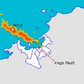
| güncel | 08.10, 6 Mayıs 2005 |  | 246 × 246 (11 KB) | Oarih~commonswiki | Map of Fukuoka City showing epicentre of March 20th quake and rough map of subsequent seismic activity along with location of the Kego fault. Made using data from [http://www.sevo.kyushu-u.ac.jp/HYPO/index.html] and maps from Japanese Wikipedia with the |
| 06.33, 3 Mayıs 2005 |  | 246 × 246 (11 KB) | Oarih~commonswiki | Map of Fukuoka City showing epicentre of March 20th quake and rough map of subsequent seismic activity along with location of the Kego fault. Made using data from [http://www.sevo.kyushu-u.ac.jp/HYPO/index.html] and maps from Japanese Wikipedia with the | |
| 06.32, 3 Mayıs 2005 |  | 246 × 246 (3 KB) | Oarih~commonswiki | Map of Fukuoka City showing epicentre of March 20th quake and rough map of subsequent seismic activity along with location of the Kego fault. Made using data from [http://www.sevo.kyushu-u.ac.jp/HYPO/index.html] and maps from Japanese Wikipedia with the |
Dosya kullanımı
Bu görüntü dosyasına bağlantısı olan sayfalar:
Küresel dosya kullanımı
Aşağıdaki diğer vikiler bu dosyayı kullanır:
- en.wikipedia.org üzerinde kullanımı
- fr.wikipedia.org üzerinde kullanımı
- ja.wikipedia.org üzerinde kullanımı
- ja.wikinews.org üzerinde kullanımı

